PhD Top Stories
Tommaso Pivetta
Satellite gravimetry for planetary exploration
Doctoral Programme in Earth science, Fluidynamics, Mathematics. Interactions and methods
Knowledge of the internal structure and physical properties of the planets is a fundamental task in order to understand the planets evolution, hypothesize the presence of life and optimally plan future exploration missions. Usually the first data at disposal rely on remote observations from Earth or from satellite missions such as the Mars Orbiter Laser Altimeter (MOLA), which mapped in great detail the Mars topography. Besides the topography, the gravity field is another datum easily obtainable from remote observations. The gravity field, in fact, is non-uniform and its spatial variations can be calculated by measuring the perturbations induced by the planet to satellites orbit. Spatial variations of gravity, or as commonly referred “gravity anomalies”, offer information on the density distribution inside the planet and, together with topography, help in unveiling geological structures which can testify past/present geodynamic processes. In the Earth case the joint analysis of topography/bathymetry and gravity data lead to estimate mantle and crust thicknesses, to study the mechanical properties of the lithosphere and also to detect the presence of crustal inhomogeneities due to sedimentary basins or volcanic areas-

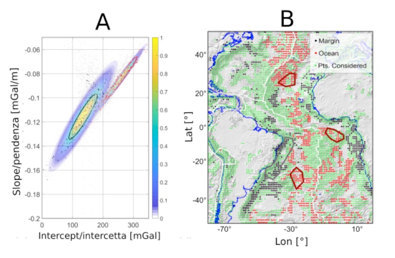
Figure 1: A) Scatter plot between regression’s slope and intercept (red: oceanic areas; black: continental margin). The colored areas report the likelihood functions employed for classifying the points. B) Pixel classifications in the Atlantic region; thick lines bound the areas used for estimating the likelihood functions.
Usually the studies involving gravity and topography observations exploit modelling techniques in order to reconstruct the underground density distribution. However, such methods require a lot of constraints to make the final model unique. For several areas of the Earth and for other planets such constraints are frequently scarce or even absent. In order to obtain some information on the main geological structures of a planet we developed and tested a simple statistical method for analyzing the correlation between topography and gravity. The method subdivides the planet surface into several windows, in which a linear function between topography and the corresponding gravity values is fitted. The regression parameters (slope and intercept), and their spatial distribution represent a wealth of data: in order to give them a geological/geophysical interpretation we preliminary performed some synthetic tests on controlled and realistic geodynamic scenarios. Then we applied the method to the observed gravity and topography data in the South America and Atlantic Ocean region. We found that the spatial distribution of the regression coefficients is deterministic and it is useful to classify areas with similar crustal structure. In Figure 1A we show two clusters (black and red dots) of the regression parameters which correspond to the continental margin and to the oceanic crust. The outlines of the areas are shown in Figure 1B with the red and black solid lines; each point in this Figure is associated to a pair of regression parameters. Starting from these two clusters we then automatically classify all the remaining points which at the end seem to be coherent with independent geological studies.
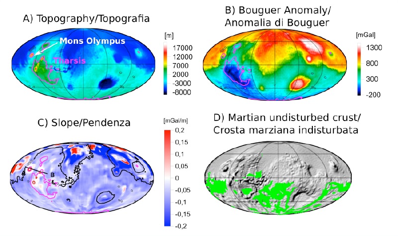
We then applied the method for studying the internal structure of Mars: figures 2A and 2B show the topography and the gravity anomalies (in this case the Bouguer anomaly is shown), while figure 2C illustrates the spatial distribution of the linear coefficient of the regression lines. We observe how well the method identifies areas characterized by intense volcanic activity (Tharsis region), which include the Olympus Mons, the second tallest volcanic mount in the solar system. The figure 2D, finally, plots a classification of the Martian terrenes, calculated in a similar way as done in the Earth case, which seems to identify areas subjected to less volcanic activity with respect to the Tharsis region. With this study we have presented a new fast and simple method for detecting and characterizing the underground geological structures. Since only topography and gravity are required, the analysis is particularly apt for exploring Earth regions as well as other planets where the available constraints for modelling are scarce.

Figure 2: A) Mars topography; B) Bouguer gravity anomaly; C) spatial distribution of the slope of the regression lines, calculated between topography and Bouguer anomalies; D) green dots: undisturbed Martian crust according to our classification.
Authors and affiliations
Tommaso Pivetta1, Carla Braitenberg1Contact
Tommaso Pivetta, email: tpivetta@units.itReference
T. Pivetta, C. BraitenbergSensitivity of gravity and topography regressions to Earth and planetary structure
Tectonophysics 774, 228299 (2020)
DOI: 10.1016/j.tecto.2019.228299
Informazioni aggiornate al: 04.12.2020 alle ore 08:00
Contact: Webmaster - Università di Trieste pagina curata da: Research Doctorate

Piazzale Europa, 1 - 34127 - Trieste, Italia -
Tel. +39 040 558 7111 - P.IVA 00211830328
C.F. 80013890324 - P.E.C. ateneo@pec.units.it


